[Printable]
Share

How not to navigate the south pacific

Posted: Thu 3rd April 2008 in Blog
Position: 11° 29.4' S, 143° 33.3' W

Oh boy I wish I had a copy of "Charlie's Charts of French Polynesia". Actually I do. I permanently loaned it to Sam on Ramprasad when I brought it home from Ornen in 1999. It would be churlish to have ask for it back after 9 years, when he is now queuing up for the the Panama Canal and his first pacific crossing.

Apparently the Canal is like the London Underground. Its on strike. So he may have to spend some quality time in Colon, poor bloke. Meanwhile I'm headed for the "Murderious Archipelago" with out the book that tells me how to negotiate the atol passes to access the laggony goodness within.

I've been naughty, I took a digital camera aboard another yacht and took photographs of the appropriate pages of the book. Not practical by it worked. We're now headed for Manihi ( I have so given up trying to pronounce the south pacific). Then maybe Ahe, and defiantly Ranigroa.
Map
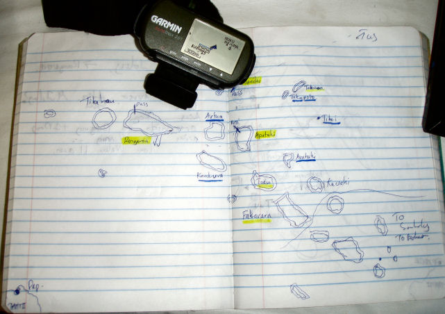
The Image above is my Chartlet of the Tuamoutos, Items underlined in blue are murderous "9kns current and coral heads in the pass" etc
Highlighted - Should be able to get in, without trauma. Underlined, maybe at slack water.

The boat is moving nicely, should be in crystal clear lagoon by the day after tomorrow.

Atill? Atoll? Atull? WTF?

There are 3 sorts of Islands in the Pacific.

1. Volcanic, and young. The Marquesas are an example. The islands have forced them selves up from the deep ocean by volcanic action. They are surrounded by cliffs. Coral may be eaking a living on the edge.

2. Volcanic medium age. The Coral around the edge grows an sustains its self, forming a ring around the island. The island is meanwhile eroding. What you end up with is a tall volcanic island surrounded by a lagoon with a reef on the edge. Like Castaway with Tom Bloody Hanks!. Bora Bora's a classic example.

3. Ancient. Assume the the erosion continues, eventually the whole volcano will disappear. The erosion will the stop at water level, the coral protects it from the waves, a shallow lagoon forms where the volcano once was. The Coral still stays, forming an empty lagoon who's tallest point is the palm tree on the surrounding reef. The Tuamoutos are all like this. The top of the Island is 2ft high, not counting the palm trees!

The Islets on the side of the coral reefs are called "Motu", for instance Rangiroa has 240 islets in a ring, with a huge shallow lagoon inside. The big gaps between Motu are called passes. Unfortunately, the tide rises and falls, and the entire rise for the Lagoon has to flow in and out through the passes. This kicks up eddies, overalls and nasty currents. Add the total irrelevance of these atolls to international shipping explains their poorly surveyed state, the ancient surveys don't include the tendency of coral to grow...... The maximum height of on Palm tree (radar absorbent), the sharp coral and you've got a cruising ground that deserves respect. So I'm drawing pictures, and looking at blury photos on digital cameras. Don't do as I do people.

[Printable]
Share

How not to navigate the south pacific

Posted: Thu 3rd April 2008 in Blog
Position: 11° 29.4' S, 143° 33.3' W

How not to navigate the south pacific

Oh boy I wish I had a copy of "Charlie's Charts of French Polynesia". Actually I do. I permanently loaned it to Sam on Ramprasad when I brought it home from Ornen in 1999. It would be churlish to have ask for it back after 9 years, when he is now queuing up for the the Panama Canal and his first pacific crossing.

Apparently the Canal is like the London Underground. Its on strike. So he may have to spend some quality time in Colon, poor bloke. Meanwhile I'm headed for the "Murderious Archipelago" with out the book that tells me how to negotiate the atol passes to access the laggony goodness within.

I've been naughty, I took a digital camera aboard another yacht and took photographs of the appropriate pages of the book. Not practical by it worked. We're now headed for Manihi ( I have so given up trying to pronounce the south pacific). Then maybe Ahe, and defiantly Ranigroa.

Map
The Image above is my Chartlet of the Tuamoutos, Items underlined in blue are murderous "9kns current and coral heads in the pass" etc
Highlighted - Should be able to get in, without trauma. Underlined, maybe at slack water.

The boat is moving nicely, should be in crystal clear lagoon by the day after tomorrow.

Atill? Atoll? Atull? WTF?

There are 3 sorts of Islands in the Pacific.

1. Volcanic, and young. The Marquesas are an example. The islands have forced them selves up from the deep ocean by volcanic action. They are surrounded by cliffs. Coral may be eaking a living on the edge.

2. Volcanic medium age. The Coral around the edge grows an sustains its self, forming a ring around the island. The island is meanwhile eroding. What you end up with is a tall volcanic island surrounded by a lagoon with a reef on the edge. Like Castaway with Tom Bloody Hanks!. Bora Bora's a classic example.

3. Ancient. Assume the the erosion continues, eventually the whole volcano will disappear. The erosion will the stop at water level, the coral protects it from the waves, a shallow lagoon forms where the volcano once was. The Coral still stays, forming an empty lagoon who's tallest point is the palm tree on the surrounding reef. The Tuamoutos are all like this. The top of the Island is 2ft high, not counting the palm trees!

The Islets on the side of the coral reefs are called "Motu", for instance Rangiroa has 240 islets in a ring, with a huge shallow lagoon inside. The big gaps between Motu are called passes. Unfortunately, the tide rises and falls, and the entire rise for the Lagoon has to flow in and out through the passes. This kicks up eddies, overalls and nasty currents. Add the total irrelevance of these atolls to international shipping explains their poorly surveyed state, the ancient surveys don't include the tendency of coral to grow...... The maximum height of on Palm tree (radar absorbent), the sharp coral and you've got a cruising ground that deserves respect. So I'm drawing pictures, and looking at blury photos on digital cameras. Don't do as I do people.